
This work by New American History is licensed under a Attribution-NonCommercial-ShareAlike 4.0 (CC BY-NC-SA 4.0) International License. Permissions beyond the scope of this license may be available at newamericanhistory.org.
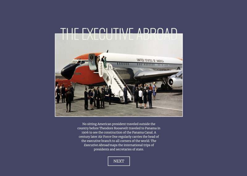
The Executive Abroad
International Travels of the President and Secretary of State in the Modern Era
Read for Understanding
No sitting American president traveled outside the country before Theodore Roosevelt traveled to Panama in 1906 to see the construction of the Panama Canal. A century later Air Force One regularly carries the head of the executive branch to all corners of the world. The Executive Abroad maps the international trips of presidents and secretaries of state.
Key Vocabulary
Abroad - in a foreign country
Air Force One - the aircraft used to carry the U.S. president
Commander-in-Chief - the leader in charge of the armed forces of a country, in the U.S., this is one of the many roles of the president.
Data - raw information in the form of numbers, text, or other symbols.
Diplomat - a person who manages international relations, especially between countries
Executive - a branch of the federal government including the president, vice president, and Secretary of State, among others. The American president is referred to as the chief executive
Foreign - having to do with countries outside of one’s own homeland
Geopolitics - the interaction of geography and power in the relations between nations, including foreign policy
Head of State - one of the many roles of the U.S. president that includes representing the nation at official events and meetings
Infographic - a visual image such as a chart or diagram used to represent information or data
Secretary of State - a cabinet-level position in the U.S. government, appointed by the president and approved by the Senate. The secretary serves as the president’s main foreign affairs adviser.
Engage:
In what ways do cartographers, historians, and data scientists visualize data to help tell a story?
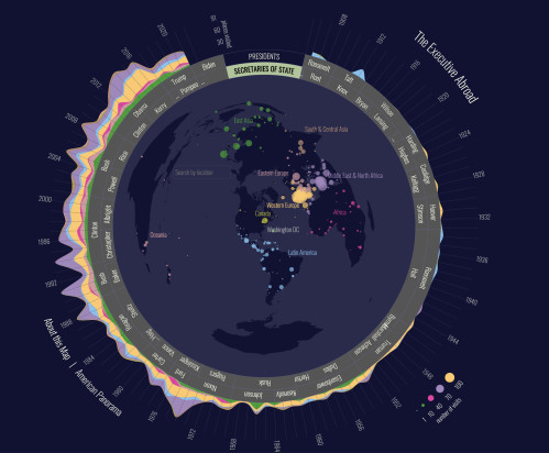
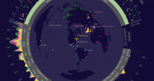
Data is all around us! We have more access to data, in the form of facts, numbers, statistics, and visual representations of information than in any other era in modern history. One of the challenges of having access to so much data is figuring out how to make sense of it. Cartographers, historians, and data scientists have used a variety of techniques to help do that. These include maps, charts, and graphs that show patterns and tell stories. The Executive Abroad is an unusual map created by the Digital Scholarship Lab at the University of Richmond in Virginia. It uses data about the travels of 20th and 21st-century presidents and secretaries of state to help illustrate the role of the executive branch of government in diplomacy and foreign relations.
Take a few minutes to explore the image on the homepage, then select NEXT to view this “How to Use This Map” infographic. Explore on your own or with a partner, as directed by your teacher.
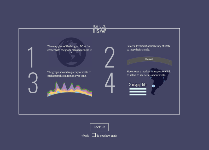
- What do you notice?
- How does the graph differ from other types of graphs you have seen before?
- What types of data are represented on the infographic?
Select ENTER to go to the live map. Take a few minutes to explore the map on your own or with a partner, as directed by your teacher. You may refer back to the infographic as needed.
Explore:
How does The Executive Abroad tell the story of the role of the president as commander-in-chief and head of state?
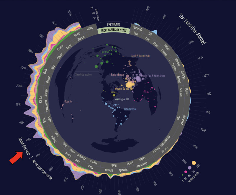
The “About this Map” section of the map gives us some context about the data presented on the map. Take a few minutes to read through this section carefully. (The red arrow on the image below will help you locate this section on the map!).
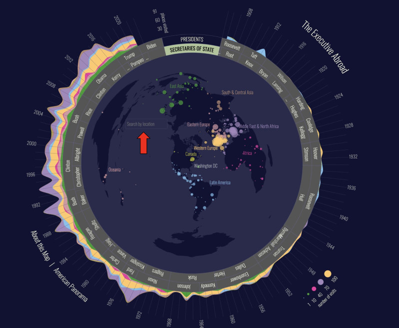
Now take some time to compare and contrast some of the presidential and secretary of state data from a few different time periods. Use the search box located in the middle of the globe to search for a specific country by location, or click on a location anywhere on the globe. (The red arrow on the image below will help you locate the search box on the map).
- How is color used on the map to represent data?
- What continents, regions, or countries are most frequently visited by the presidents or secretaries of state whose data you chose to view?
- What continents, regions, or countries were visited less frequently?
- Were there any places you explored where a U. S. president or secretary of state does not appear to have visited?
Next, take some time to analyze a few travels of more presidents and secretaries of state. Pay careful attention to the notes that appear underneath the names of the countries visited. Select several of these and look for words or phrases you may see repeated. Note any unfamiliar words you may need to look up and add to your personal vocabulary.
- What are some of the most frequently mentioned occasions or reasons listed for these travels?
- Do you see any patterns when comparing the reasons listed for presidents and their secretaries of state? What patterns do you notice when comparing these reasons across multiple presidencies?
Turn and talk to an elbow partner. As you continue to explore the map, see if you are able to locate some examples of the president traveling in the role of commander-in-chief. Discuss your findings with your elbow partner.
- Are there some presidents who seemed to travel in this role more often than others?
- What might be some reasons for them to travel more often in this role?
- In which time periods did presidents act most often in this role?
Explore the map further, looking for examples of the president acting in the role of head of state.
- Which presidents did you observe traveling more frequently in this role?
- Do you see any patterns between the role the president is playing and the geographic locations where they are traveling?
- How do their secretaries of state assist them in this role?
- Do you see any patterns between the travel destinations of certain presidents and their secretaries of state?
For more information about the many roles of the president and their cabinet members, including the secretary of state, check out this article from Scholastic, or visit the White House website.
Your teacher may ask you to record your answers on an exit ticket.
Explain:
What geographic patterns can you see when exploring the foreign travels of the president and secretary of state?
You have explored the various roles the president and the secretary of state have played in traveling abroad to represent the United States as both diplomats and military commanders. Now let’s explore their travels from a geographic perspective.
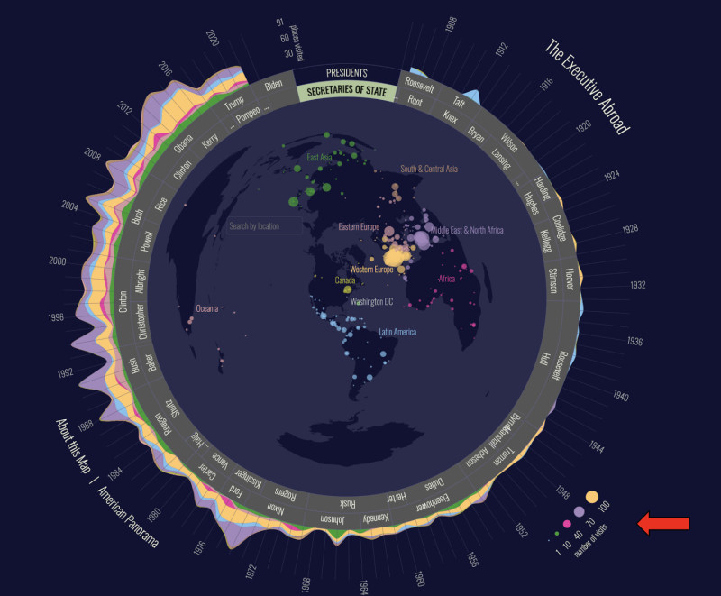
Refresh your memory about the use of color on the map, using both the “How to Use This Map” infographic and the color-coded map key. (Use the red arrow to help locate this feature on the map.)
Quick Write: What is the relationship between the colors on the map and the color on the graph around the edges of the map? Write for three minutes, then share with your elbow partner. Note any new ideas you learned from each other at the bottom of your Quick Write.
Select two continents on the map (with the exception of Antarctica!) and compare and contrast the frequency of official visits by U.S., presidents, and secretaries of state to each one.
- How does the size of the marker change as you explore different locations across the globe?
- How is this represented on the maps? Think of two or more ways.
- What happens to the size and shape of the continents as they are presented on this map?
- What regions, countries, or continents seem to have the most influence on the travels of the presidents or secretaries of state?
- What might explain the frequent or infrequent visits to some countries compared to others?
Your teacher may ask you to record your answers on an exit ticket.
Elaborate:
What technological advances have changed the way presidents interact with other nations over time?
In the About this Map section, you read about the beginnings of the use of Air Force One and the modern era of presidential travel and security. Read this excerpt from the White House website for more information about presidential air travel.
- What barriers existed to early presidential travel?
- How might this have impacted the relationships between the United States and other nations in the past?
- How were these barriers removed over time?
- What form(s) of transportation was used prior to the modern era when air travel became more common for presidents traveling abroad?
- How has technology impacted the way the U.S. government interacts with other nations?
- How has technology been used strategically by the president when acting in the role of commander-in-chief in the modern era?
Take a few moments to look at the most recent data depicted for President Joe Biden.
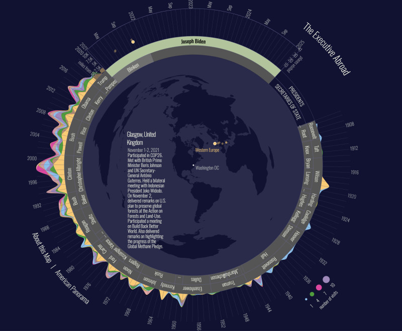
- What is unusual about Biden’s travels in his first term of office compared to that of his recent predecessors?
- What might explain this pattern?
- How might President Biden have used other forms of technology during this time period for meeting with foreign leaders? (Where might you find more information on this topic?).
Your teacher may ask you to record your answers on an exit ticket.
Extend:
What types of archives or primary sources could we use to find out more about the stories behind the map?
Presidential libraries and museums contain the personal and official records of past presidents. The presidential libraries for every president beginning with Herbert Hoover are administered by the National Archives. Read more about how these public archives were first created, and how they are now open to the public and accessible for historical research.
Select one of the presidents you explored on The Executive Abroad, and explore their presidential library website to learn more about their presidency. Look for information about the specific events, ceremonies, or meetings you observed on the map.
- What new information did you learn about the people, places, and events that were most significant to that president’s term in office?
- What did you find most surprising?
- What did you find most interesting?
- What did you find most troubling?
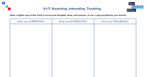
You may record your answers on this graphic organizer to help you summarize your ideas.
Another fun way to learn more about presidential travels is to explore the connections between The Executive Abroad and other material in Bunk. Take a few minutes to look at the map in Bunk and explore the Connections feature.
- What connections did you discover on Bunk?
- Select at least two of the different types of connection icons and continue to search for more information about the same president whose presidential library site you explored earlier.
- Try using the search box or the new Bunk mapping search tool in the top right corner of the website to search for the president you have been researching. (Use the red arrow in the image above to locate these search features.) Look again for specific references to the places, events, and milestones you recall reading about on the map. You may record some additional information on your S-I-T graphic organizer.
If time permits, your teacher may allow you to share your research with our classmates using a digital gallery walk where you display the map and one or more interesting connections you found on Bunk.
Your teacher may ask you to record your answers on an exit ticket.
Citations:
“Air Force One.” The White House. The United States Government, July 12, 2022. https://www.whitehouse.gov/about-the-white-house/the-grounds/air-force-one/.
Presidential Libraries. National Archives Foundation, October 21, 2013. https://archivesfoundation.org/visit/presidential-libraries/.
Nelson, Robert K. et al., “The Executive Abroad,” American Panorama, ed. Robert K. Nelson and Edward L. Ayers, June 27, 2017. https://dsl.richmond.edu/panorama/executiveabroad.
Nelson, Robert K. et al., “The Executive Abroad,” American Panorama, ed. Robert K. Nelson and Edward L. Ayers. Bunk. New American History. The University of Richmond, June 27, 2017. https://www.bunkhistory.org/resources/the-executive-abroad.
“S-i-T: Surprising, Interesting, Troubling-Teaching Strategy.” Facing History and Ourselves. Facing History and Ourselves, July 12, 2017. https://www.facinghistory.org/resource-library/s-i-t-surprising-interesting-troubling.
“The Executive Branch.” The White House. The United States Government, July 12, 2022. https://www.whitehouse.gov/about-the-white-house/our-government/the-executive-branch.
Ward, Teresa. “Six Ways to Use Quick Writes to Promote Learning: On Course.” College Educator Workshops & Conferences. On Course Workshop, July 22, 2020. https://oncourseworkshop.com/life-long-learning/six-ways-use-quick-writes-promote-learning/